|
Ponca-Lost Valley Recreational Area
Buffalo River National Park
Arkansas Scenic Byways
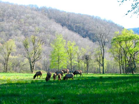
Wild elk herd grazing in Boxley Valley along the Upper Buffalo River
The Upper Buffalo River runs through Boxley Valley near the village of Ponca. It is about 25 miles west of Jasper and Scenic Highway 7 via Highway 74. Canoe float trips start either at the Boxley Bridge or the low bridge near Ponca. Upstream from the Boxley Bridge the river is a stream that would only be navigable in early spring. Canoe rentals and outfitting is available in Ponca. Also in Ponca is the Elk Education Center run by the Arkansas Game & Fish Commission. The elk herd in the park has grown to about 450 animals and are frequently seen in Boxley Valley.
For hikers, in addition to several trails along the river, there is hiking in two adjacent wilderness areas: Ponca Wilderness Area and the Upper Buffalo Wilderness Area. For those not interested in backcountry camping, the Lost Valley Campground has 15 campsites, with a few suitable for small RVs or tent trailers. The tent sites are very nice, set away from the parking area and generous spacing between the sites. The bathroom has running water and flush toilets but there are no electric hookups. It is a very pretty and secluded little campground. Camping is first come first served. A major feature of Lost Valley is a 2+ mile scenic hiking trail along Clark Creek with several interesting natural formations, including Eden Falls.
We've previously visited other recreation sites and camping areas along the Buffalo River: Tyler Bend and Buffalo Point. The campgrounds at these two areas are full-service with showers and several sites with electric hookups. Each area also has several scenic hiking trails.
|
~ ~ ~ ~ ~ Clicking on thumbnail images will bring up larger photos ~ ~ ~ ~ ~ |
Lost Valley Recreation Area

While a number of campers at Lost Valley use this a base of operations for floating the river or fishing, another attraction is the Lost Valley Trail. 
Starting along the trail we came upon this unusual (to us) flower among some Wood Violets. We later discovered it is a Wake Robin or a red Trillium. |

< < < This formation is called the Natural Bridge where Clark Creek has carved a 50 foot long tunnel through the limestone.

Here is the last section of Eden Falls as it cascades into a pool of water. In total the four cascades of the falls drop 170 feet. > > > |

< < < A pretty little waterfall from a spring that empties into Clark Creek.

This is typical of the towering limestone bluffs frequently found along the Buffalo River
|
|
Upper Buffalo River - Ponca Wilderness Area

The Ponca low-water bridge is a popular put-in spot for canoeing the Upper Buffalo River. We, however, were hiking the trail that runs adjacent to and above the river.
Shortly after leaving the bridge and hiking up the trail we came upon this old log homestead - the James Villines home and farmstead was constructed in various stages from 1854 to 1880. |
|


The trail climbs steeply along the edge of limestone bluffs and through rock-outcroppings.
|
|

Some great views of the river far below the trail.
Looking upstream from the Ponca low water bridge. This stretch of the Buffalo offers decent fishing for smallmouth bass and entertaining canoeing during the spring. |
|
 Go Here for info on Buffalo Point Campground & Recreation Area - Buffalo River National Park Go Here for info on Buffalo Point Campground & Recreation Area - Buffalo River National Park
|
|
Ozarks & Buffalo River Travel & Visitor Links
|
|
|
 |
Scenic Drives & Byways
 Lake Superior Circle Tour, Part 1. & Circle Tour Part 2. - Lake Superior Circle Tour, Part 1. & Circle Tour Part 2. -
Minnesota, Wisconsin, Upper Peninsula, and Ontario
Great River Road Scenic Byway, Part 1. - Galena, Illinois to
Prairie Du Chien, Wisconsin
Galena, IL
Dubuque, IA
Prairie Du Chien, WI
Great River Road Scenic Drive, Part 2. - LaCrosse, Wisconsin to
Winona, Minnesota
La Crosse, WI
Winona, MN
Fall Color Train
Great River Road, Part 3. - Winona, Wabasha to Red Wing, Minnesota
Wabasha, MN
Red Wing, MN
Ozarks Mountains Scenic Drives - Ozarks National Forest Scenic Drives
and Scenic Highway 7
Arkansas Ozarks Scenic 7 Byway
Mountain View, Arkansas
Hot Springs, AR and Hot Springs National Park
Buffalo National River and Buffalo River National Park
|
|
|
|
©QuiltingPathways.com 2006 - 2022 |
|


~ ~ ~
Quilt Shops
along
Arkansas Scenic
Highway 7
and
the Ozarks Mountains
~ ~ ~
Save Money On Hotel
& Motel Booking
- Internet Rates -
Superior Trails
Lodging Service
Scenic Drives
& Scenic Travel
|

)
)
)
)
)
)
)
)
)
)
)
)