|
Lake Superior Circle Tour Scenic Drive - Part 1
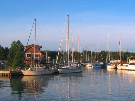
Harbor Scene, Cornucopia, Wisconsin - Bayfield Peninsula
The Lake Superior Circle Route runs through three states and one Canadian province. Lake Superior is the largest freshwater lake in the world, based on surface area, and the third largest in volume exceeded only by Lake Baikal in Siberia and Lake Tanganyika in Africa. If you were able to walk the shoreline of Lake Superior, your trek would cover 2,726 miles. About 90% of that shoreline is forested and relatively uninhabited.
The Circle Route Scenic Byway around the lake runs through picturesque villages, over crystal clear rivers, by spectacular waterfalls, over the highest mountains in the midwest, alongside panoramic beaches, through towering forests, and . . . goes by some neat quilt shops!
A comprehensive travelogue of the Circle Tour can be found on our sister site, SuperiorTrails.com, so here we only offer a brief digest of some highlights of this scenic drive.
~ ~ ~ Click on thumbnails for a larger image ~ ~ ~
Minnesota's North Shore
Travel Minnesota's Scenic Highway 61 from Duluth, MN to Grand Portage. Duluth's lakewalk, canal park shopping, and numerous city parks are highlights of the many visitor attractions this port city offers. Traveling along the North Shore one finds many beaches that are a rock picker's delight, outstanding camping and hiking opportunities along the entire drive, abundant rivers and impressive waterfalls, picturesque villages and historic sites, and high bluffs, impressive rock outcroppings and lush forests lining the drive.
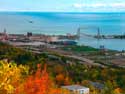
< < < The Duluth Harbor from the Enger Park Tower. More info on Duluth, MN travel attractions here.
The Angry Trout Cafe in Grand Marais, Mn > > >
|
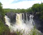
< < < The spectacular "High Falls" near Grand Portage, Mn. The half-mile trail and overlook to this falls is handicap accessible |
 Travel Map of Minnesota's North Shore Scenic Highway Travel Map of Minnesota's North Shore Scenic Highway
|
|
Wisconsin's South Shore
While the Minnesota North Shore drive runs through hills and mountains and along a rugged coastline formed by some of the earth's oldest rocks (igneous basalt and rhyolite), the Circle Route traveler gets a different experience in Wisconsin. Wisconsin's South Shore drive offers many miles of sandy beaches, more coastal villages, and sandstone outcroppings instead of basalt. Wisconsin's forests are a little more diverse than Minnesota's, offering a greater variety of hardwoods mixed in with the pine and balsam forests.
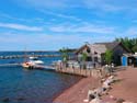
The drive from the port city of Superior follows highway 13 to the Bayfield Peninsula, along the way going through some quaint fishing villages that are now largely occupied by artisans and establishments serving the touring public. The village of Bayfield, Wisconsin is the crown jewel of the Wisconsin branch of the Lake Superior Circle Tour, not only for its preservation of historic buildings and its seaside amenities, but as the gateway to the outstanding Apostle Islands National Lakeshore park.
The drive, along US Highway 2, east of Ashland to the Michigan border is largely away from the lake, but offers some scenic side trips to state and county parks offering waterfalls, hiking trails, and camping amenities. This portion of the drive is especially attractive during fall color tour time.
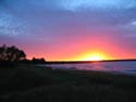
< < < Sunset over Siskiwit Bay, Cornucopia, Wisconsin
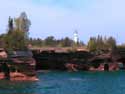
Apostle Islands Sea Caves and Devil's Island
Lighthouse, Bayfield, Wi > > >
|
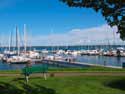
< < < Jo pauses for a rest on a bench at Bayfield's harbor park.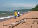
Jo and sister Donna do some beach combing along Myer's Beach near Cornucopia, Wi. > > >
|
| Travel Map of Wisconsin's South Shore Superior Scenic Highways |
|
Part 2. Lake Superior Circle Tour -
Michigan's South Shore & Ontario's North Shore
~ ~ ~ ~ ~ |
 Directory of Quilt Shops Around Lake Superior Directory of Quilt Shops Around Lake Superior
|
 |
Directory of Scenic Drives & Byways
 Lake Superior Circle Tour, Part 1. & Circle Tour Part 2. - Lake Superior Circle Tour, Part 1. & Circle Tour Part 2. -
Minnesota, Wisconsin, Upper Peninsula, and Ontario
Great River Road Scenic Byway, Part 1. - Fulton to Galena, Illinois to
Prairie Du Chien, Wisconsin
Fulton, IL
Galena, IL
Dubuque, IA
Prairie Du Chien, WI
McGregor, IA
Great River Road Scenic Drive, Part 2. - LaCrosse, Wisconsin to
Winona, Minnesota
La Crosse, WI
Winona, MN
Fall Color Train
Great River Road, Part 3. - Winona, Wabasha to Red Wing, Minnesota
Wabasha, MN
Red Wing, MN
Ozarks Mountains Scenic Drives - Ozarks National Forest Scenic Drives
and Scenic Highway 7
Arkansas Ozarks Scenic 7 Byway
Mountain View, Arkansas
Hot Springs, AR and Hot Springs National Park
Buffalo National River and Buffalo River National Park |
|
|
|
©QuiltingPathways.com 2006 - 2022 |
|


~ ~ ~
More Scenic Drives
and Scenic Travel
~ ~ ~
Fall Foliage
Lake Superior
Color Tours
~ ~ ~

Bayfield Wisconsin
Apple Festival
~ ~ ~
Quilt Shops
around the Lake Superior Scenic Byway
~ ~ ~
~ ~ ~
Save Money On Hotel
& Motel Booking
- Internet Rates -
Superior Trails
Lodging Service
~ ~ ~ ~
|

)
)
)
)
)
)
)