Buffalo Point Park - Buffalo National Scenic River
Arkansas Scenic Byways

Buffalo River above flood stage at Buffalo Point
The Buffalo National River is "more than just a river. The 95,730 acre park contains open farmlands, oak-hickory forests, ponds and streams, abandonded homesites, tall bluffs and box canyons." (National Park Service brochure on wild birds).
While the river is a favorite for canoe tripping, recreational floating and smallmouth bass fishing, the park surrounding the river offers great appeal to naturalists and photographers for its woodland variety, wildflowers, birds, and wild mammals. Hikers can spend several days in the park exploring 30 marked day hiking trails or connect with Ozarks backpacking trails. The trails offer a wide variety of features and difficulty. There are easy to moderate trails visiting waterfalls, caves, hardwood forests, bluff-top views, and historic pioneer settlements. There are also strenuous climbs with a 1100 foot elevation change and offering views of the highest waterfall between the Rockies and Appalachians.
The largest campground for park visitors is Buffalo Point. This camp was originally the Arkansas Buffalo River State Park developed as CCC project in the 1930s. Many of these original structures remain. Since being incorporated into the Buffalo River National Park, the campground has been expanded and modernized with shower facilities, electrical and water hookups, paved roads, and nicely landscaped tent and RV pads. Buffalo Point offers 83 drive-in campsites, 21 walk-in tent sites, 5 group sites, and 12 cabins. There is river access for canoeing, boat launching, and swimming. There are 4 varied and scenic hiking trails from the campground and two more hiking trails in the nearby Rush Creek historic district.
Our visit was in early April 2008 two weeks after a late spring 11 inch wet snowfall followed a few days later by a 10 inch two day rain. This flooded the Buffalo River valley with a torrent of rushing water that peaked at 58 feet at Buffalo Point, putting all but 22 campsites under water and raising the river level 46 feet *over* the normal flood stage level of 12 feet. One consequence of the flood was the normally clear, turquoise colored river was brown and opaque. The campsites were being repaired during our visit; the boat and canoe launch area was still under about 10 feet of water and was badly washed out so it could be a while before boats could be launched here.
|
| Camping

Some of the campsites are two-tiered with a car or RV parking area above and the picnic table, grill, and tent pad below.

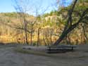
< < < One of the campsites that was under water two weeks ago and now overflowing with a foot of sand! Normally this site is 25 - 30 feet above the water level - but not two weeks prior. |
 |
Scenic Drives & Byways
 Lake Superior Circle Tour, Part 1. & Circle Tour Part 2. - Lake Superior Circle Tour, Part 1. & Circle Tour Part 2. -
Minnesota, Wisconsin, Upper Peninsula, and Ontario
Great River Road Scenic Byway, Part 1. - Galena, Illinois to
Prairie Du Chien, Wisconsin
Galena, IL
Dubuque, IA
Prairie Du Chien, WI
Great River Road Scenic Drive, Part 2. - LaCrosse, Wisconsin to
Winona, Minnesota
La Crosse, WI
Winona, MN
Fall Color Train
Great River Road, Part 3. - Winona, Wabasha to Red Wing, Minnesota
Wabasha, MN
Red Wing, MN
Ozarks Mountains Scenic Drives - Ozarks National Forest Scenic Drives
and Scenic Highway 7
Arkansas Ozarks Scenic 7 Byway
Mountain View, Arkansas
Hot Springs, AR and Hot Springs National Park
Buffalo National River and Buffalo River National Park
|
|

)
)
)
)
)
)
)
)
)
)
)
)